
People in Cusco have talked about the chinkanas for more than four centuries: underground passages that, according to chroniclers of the colonial period and stories passed down through generations, linked Saqsaywaman (Sacsayhuamán) with Qorikancha (Coricancha), the principal temple of Tawantinsuyu. Since 2025, a team of Cusco archaeologists has said it detected a main axis of about 1,750 metres with ground-penetrating radar, and it has been excavating at Saqsaywaman with a permit from Peru’s Ministry of Culture. Here is what the old sources say, what modern research has found and what still needs to be proven.
Published on 20 November 2026. This is ongoing research: the tunnel’s measurements come from the team itself, in press conferences and interviews, and we have found no peer-reviewed scientific publication and no statement from the Ministry of Culture confirming or ruling out the route. We will update this article when new verifiable data appear.
The essentials
- What it is: chinkana comes from the Quechua verb chinkay, “to get lost”. It means “a place where one gets lost” and, in Inka works, a tunnel or labyrinth (Academia Mayor de la Lengua Quechua).
- What the chronicles say: Martín de Murúa, an anonymous Jesuit chronicle and Guaman Poma describe a passage from Saqsaywaman to Qorikancha. Garcilaso describes a labyrinth beneath the towers, without saying it reached the temple.
- What the team says: archaeologists Jorge Calero Flores and Mildred Fernández Palomino say they have detected a main axis of about 1,750 metres, up to 2.6 metres wide and 1.6 metres high, with branches towards San Cristóbal, Callispuquio and Muyuqmarka.
- Where things stand: they have been excavating at Saqsaywaman since May 2025 with official permission. They report a passage between two towers, but no entry into the main axis.
- What is missing: a peer-reviewed publication and an official assessment. Until then, the 1,750-metre tunnel is a hypothesis with supporting evidence, not a confirmed fact.
A word for getting lost
In Quechua, chinkay means “to get lost, to go astray”, and a chinkana is “a place where one gets lost”. The dictionary of the Academia Mayor de la Lengua Quechua, based in Cusco, adds a specific sense: “tunnel, labyrinth in Inka works”. Colonial documents spell the word chingana or chincana; we use chinkana, the modern Quechua spelling, except in proper names such as that of the archaeological project.
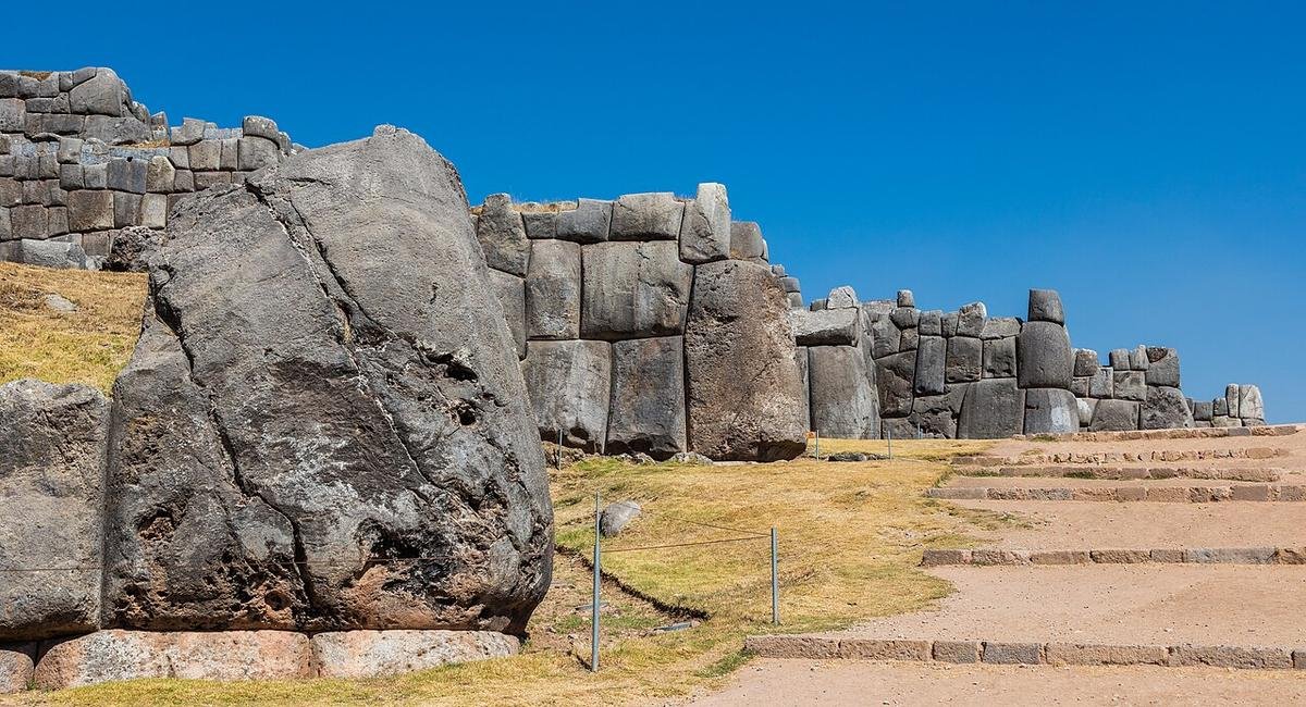
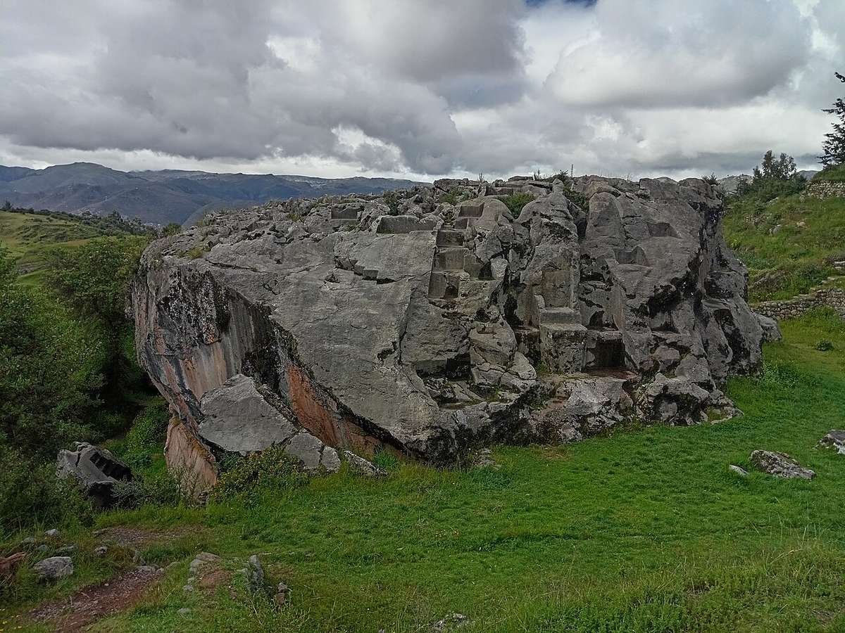
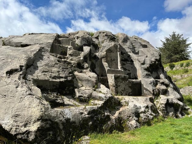
The word also names real places that can be visited today. In the Saqsaywaman Archaeological Park there are two limestone outcrops called Chinkana Grande (Hatun Chinkana) and Chinkana Chica, north of the esplanade. The Academia describes Chinkana Grande as a waka, a sacred place, built into a fault in the rock, and notes that “several myths and legends have been woven” around it: passages to distant places, vanished adventurers and hidden treasure.
These stories are part of Cusco’s oral tradition and are still alive: “the dream of almost every person from Cusco has been to find the chincanas”, Calero said in July 2026. Telling apart what tradition says from what can be proven is the challenge here.
Explained simply: what do Tawantinsuyu and Inka mean?
Tawantinsuyu is the Quechua name for the Inka state. It means roughly “the four regions together”: Chinchaysuyu, Qollasuyu, Antisuyu and Kuntisuyu. Its capital was Cusco (Qosqo).
Inka (or Inca, the traditional Spanish spelling) was the title of the ruler, and by extension it is used for the people and the period. Many researchers and the Academia Mayor de la Lengua Quechua write “Inka”; we use that form in this article.
Saqsaywaman and Qorikancha are the Quechua spellings of Sacsayhuamán and Coricancha. Qori kancha is usually translated as “golden enclosure”.
What the chronicles said
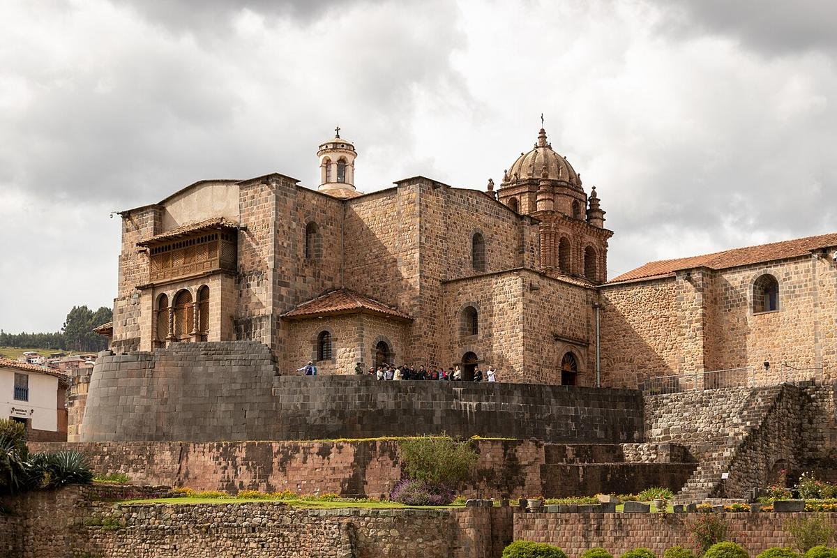
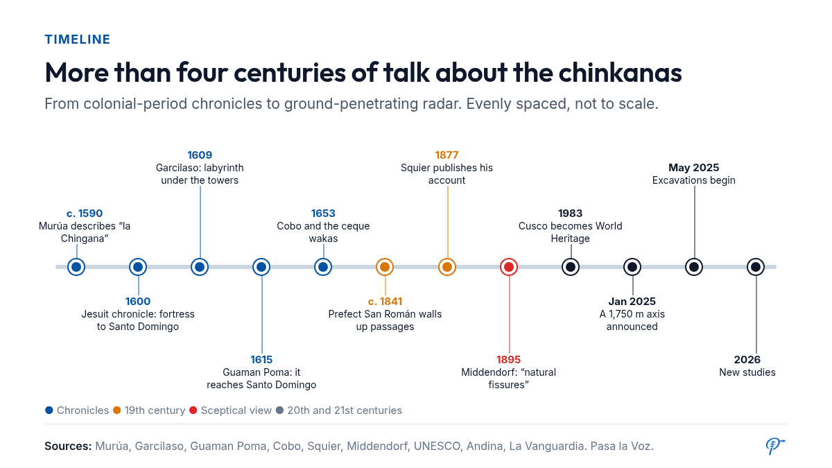
Written references begin in the period of Spanish colonization. The Mercedarian friar Martín de Murúa, in his Historia general del Perú (a first version of which is dated to around 1590), says that Tupa Inka Yupanqui had a temple built in the Cusco fortress for his wife, Mama Ocllo, “with countless doors and a carved entrance” shaped like a “serpent’s mouth”, and that through it people “went beneath the earth to the temple and house of the Sun, called Curicancha”. He adds that, according to “some old Indians”, this doorway was in “a cave now called la Chingana, which means a place where people get lost” (book I, chapter 27).
In another chapter, Murúa attributes the passage to Ausitopa, a son of Tupa Inka Yupanqui, and compares it with the “labyrinth on the island of Crete”, a European reference of his own. He also warns that by his time nobody knew where it went (book I, chapter 90).
An anonymous Jesuit chronicle of 1600, edited by Francisco Mateos in 1944, describes “the celebrated cave of Cuzco, which the Indians call Chincana, meaning a shaft or underground passage”, “a cave that the Inka kings made, very deep, which crosses the whole city through the middle, and has its mouth or entrance in the fortress” called Sarsaguán (Saqsaywaman). It runs down “from the heights along the lower part of the hill and the town or parish of San Cristóbal, and at a depth of many estados (an estado is roughly a person’s height) comes out at what is now Santo Domingo”, “the famous temple of Coricancha and house of the great Punchao” (volume 2, p. 32). The Andean chronicler Felipe Guaman Poma de Ayala, in his Nueva corónica y buen gobierno (1615), lists among the Inka fortresses the “Chingana, the hole beneath the earth”, which “reaches as far as Santo Domingo, Curi Cancha of Cuzco” (page 339 of the manuscript).
The most quoted account is that of Inca Garcilaso de la Vega, the son of a Spanish captain and an Inka noblewoman, in his Comentarios reales (1609). Garcilaso describes galleries beneath Saqsaywaman’s three towers with “so many streets and alleys” and so many identical doors that anyone entering the “labyrinth” lost their way, and that even the most experienced used “a ball of thick thread” tied to the door to find their way back. He recalls climbing to the fortress as a boy with other children, and they did not dare go further than “where the sunlight reached” (book VII, chapter 29). A caution: in that chapter Garcilaso is describing passages between the towers. Some versions circulating online attribute to him sentences about tunnels reaching Qorikancha that do not appear in his text.
| Source | Year | What it says | What it does not say |
|---|---|---|---|
| Martín de Murúa, Historia general del Perú | c. 1590-1616 | A temple in the fortress with a serpent-shaped entrance and an underground passage to Qorikancha, “la Chingana”. | Where it ran: even in his day “nobody can tell where it goes”. |
| Anonymous Jesuit chronicle of 1600 (ed. Mateos, 1944) | 1600 | A cave that the Inka kings made, very deep, from the fortress (Sarsaguán) to Santo Domingo, by way of San Cristóbal. | That the author walked the route: he relies on “all the Indians” he consulted. It gives no measurements. |
| Inca Garcilaso, Comentarios reales | 1609 | A labyrinth of galleries beneath Saqsaywaman’s towers. | That it reached Qorikancha. |
| Guaman Poma, Nueva corónica | 1615 | The “Chingana”, a hole beneath the earth that reaches Santo Domingo. | Details of construction or use. |
| E. G. Squier, Peru | 1877 | The Chingana rock near the Rodadero: natural fissures enlarged by hand; partly walled up on the orders of prefect San Román. | It does not confirm the tunnel to Qorikancha: he reports it as “a story current”. |
The 19th century: walled-up passages and first doubts
The American traveller Ephraim George Squier visited Cusco in the 1860s and published Peru (1877). Near the Rodadero he describes a limestone cliff called “the Chingana”, with natural fissures “enlarged by art”. According to Squier, its branches could no longer be followed because General San Román, as prefect of Cusco, had some passages walled up after several accidents, the last of which killed three boys.
Miguel de San Román, who later became president of Peru, was signing as prefect of Cusco in January 1841, according to documents held by the University of Notre Dame. Squier gives no date for the walling-up; Calero’s team places it after accidents between 1838 and 1842. Squier also passes on the story of two students who supposedly heard Mass in Santo Domingo from below, but presents it as “a story current”. We have found no documents confirming it: it is tradition.
Not every observer accepted the tunnel. The German physician and linguist Ernst Middendorf, who lived in Peru for 25 years, wrote in 1895 that “all kinds of fables are told” about the Saqsaywaman cave and that, in reality, these cavities were natural fissures, common in limestone terrain. Recent geological studies of the park describe the same phenomenon: limestone blocks that split apart and form natural cracks.
What might they have been for? The hypotheses
If the passages existed as the chronicles describe them, their purpose is still an open question. These are the main hypotheses, none of them proven:
- Ceremonial movement of the elite. Calero argues that they were passages “used only by the Inka and his retinue” and that the ruler may have been carried through them on a litter.
- A ritual link between sacred sites. Qorikancha was the centre of the cult of the Sun and of the ceque system. The team suggests that the Punchao, the golden image of the Sun, travelled through these passages and that the chinkana symbolised the womb of Pachamama.
- Strategic use. The anonymous Jesuit chronicle of 1600 says that, according to “all the Indians” from whom the author had information, it allowed the kings in wartime to go from the fortress to the temple “in safety and without being noticed”.
- Water and drainage. The archaeologists quoted by Infobae do not rule out that some sections were channels or aqueducts. The Academia Mayor de la Lengua Quechua describes Chinkana Chica as a passage that worked as a sluice in a water system.
- Adapted natural formations. For Middendorf and others, the visible “chinkanas” are natural cracks in the limestone, partly enlarged by Inka builders.
The idea of a “labyrinth” also calls for caution. Several chroniclers explained it with European references, such as the labyrinth of Crete. In the Andean worldview, the world below, Uku Pacha, has its own meaning, linked to the earth, the ancestors and fertility, and is not simply a place to get lost in.
Explained simply: what is a ceque?
A ceque (Quechua seq’e, “line”) was an imaginary line running from Qorikancha towards the horizon. Some 328 wakas, sacred places such as springs, stones or caves, were arranged along some forty lines, according to the list recorded by the Jesuit Bernabé Cobo in 1653.
Each ceque was looked after by a kin group (ayllu), which cared for its wakas and made offerings. The specialists R. Tom Zuidema, Maarten van de Guchte and Brian Bauer agree that Saqsaywaman’s Chinkana Grande was probably the waka called Collaconcho, the sixth on the fourth ceque of Chinchaysuyu.
Even if the tunnel is never confirmed, Chinkana Grande is already a documented part of Cusco’s sacred geography.
The Chinkana Project: from the archive to radar
Jorge Calero Flores and Mildred Fernández Palomino are archaeologists from Cusco. Calero began searching for the chinkanas in the 1990s; Fernández is a former director of the Cusco office of the Ministry of Culture, according to El País. Their project appears in Ministry of Culture documents as the Chincana Sacsayhuamán Archaeological Research Project, run by a non-profit association called Punchao.
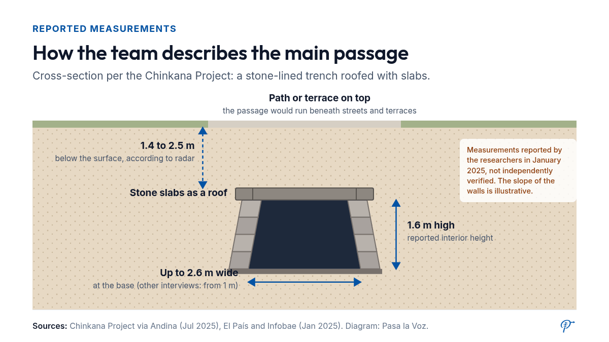
On 6 January 2025 they presented their results at Cusco’s provincial council. They explained that they first reviewed documents from the 16th to the 19th centuries to sketch a provisional route. Next came acoustic prospecting: every 50 centimetres they struck a metal plate with a sledgehammer and listened to the echo to find hollow spaces. Finally, they ran ground-penetrating radar over those areas. According to the team, at a depth of between 1.4 and 2.5 metres there was a void with sloping, trapezoidal side walls.
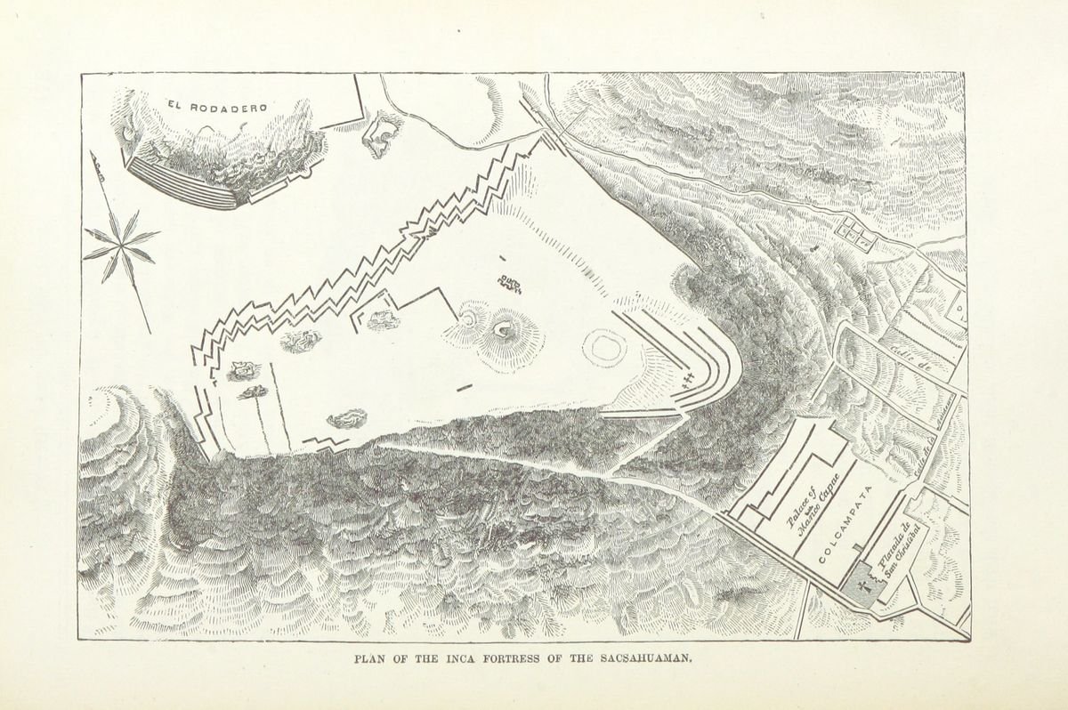
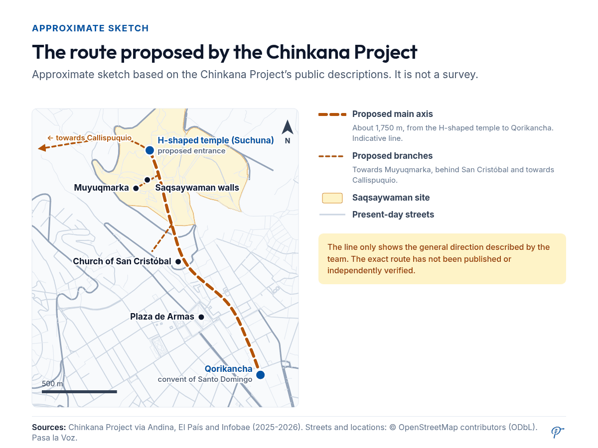
Their interpretation: a main axis of about 1,750 metres running down from an H-shaped temple next to the Suchuna or Rodadero sector, across the Saqsaywaman esplanade and on to the convent of Santo Domingo, dropping from 3,596 to 3,391 metres above sea level. It would be up to 2.6 metres wide and 1.6 metres high, built by digging a trench, lining it with stone walls and roofing it with large stone slabs used as beams, as Garcilaso describes for the passages under the towers. Paths and terraces would run on top. The team also identified three branches: towards Muyuqmarka, towards Callispuquio and behind the church of San Cristóbal.
Explained simply: how does ground-penetrating radar work?
The ground-penetrating radar (GPR) is a device pushed across the ground that sends pulses of radio waves downwards. When the waves meet a change, for example between packed earth and a hollow, part of the signal bounces back.
The team measures how long each echo takes and turns it into an image of what lies below, a bit like an X-ray in strips. A void or a buried wall shows up as an anomaly.
The key point: radar shows anomalies, not objects. A natural crack or a modern pipe can look like a passage, which is why only excavation confirms what is there.
Digging at Saqsaywaman (2025-2026)
Excavations began on 27 May 2025 with authorisation from the Ministry of Culture’s Cusco office, according to the project; a resolution from that office dated October 2026 refers to its “Excavation Unit No. 17”. Work is focused by the Suchuna sector, beneath an H-shaped structure the team calls the “Temple to Pachamama”, where it says it has found a stone shaped like a reptile’s head that it links to Murúa’s “serpent’s mouth”.
In July 2025, Calero told La Vanguardia that one of the units had exposed the passage between the Muyuqmarka and Sayaqmarca towers described by Garcilaso, and that he hoped to enter the main axis “within two or three months”. We have found no announcement that this has happened. According to History.com (March 2026), the team also found walls that appear to seal an entrance, with glazed tableware and crosses, which it reads as traces of the 19th-century walling-up.
In July 2026, Calero said new geophysical studies, such as electrical resistivity tomography, confirm “several underground corridors”, and estimated that about eight more years will be needed to understand the network. The figures vary between interviews: History.com mentions “five passages” about 2.7 metres high, while El Peruano cites four branches totalling about eight kilometres. The data are not yet consolidated.
What has not yet been proven
When the find was announced in January 2025, El País reported that “there are also those who have serious doubts”, above all because other researchers had previously claimed to have solved the mystery. In 2003, for example, the EFE news agency reported the announcement of a two-kilometre tunnel between Qorikancha and Saqsaywaman, detected by radar by a team led by the Spaniard Anselm Pi Rambla. The Association of Archaeologists of Peru shared Calero and Fernández’s announcement on social media, according to Smithsonian, but that is not the same as scientific validation.
| Claim | Who says so | Status |
|---|---|---|
| The word chinkana exists, “a place where one gets lost” | Academia Mayor de la Lengua Quechua; chroniclers | Verified |
| Chroniclers describe a passage from Saqsaywaman to Qorikancha | Murúa, the Jesuit chronicle, Guaman Poma | Verified (what the chronicles say, not the tunnel) |
| There were passages beneath Saqsaywaman’s towers | Garcilaso; 2025 excavation | Passage reported by the team, no scientific publication |
| A prefect walled up passages in the 19th century | Squier (1877) | Documented by Squier; exact date unconfirmed |
| A 1,750 m axis to Qorikancha | Calero and Fernández | The team’s hypothesis, with geophysical data; not peer-reviewed |
| Dimensions of 2.6 x 1.6 m | Calero and Fernández | Reported; figures vary between interviews |
| Official validation of the route | Ministry of Culture | Not found |
Why it matters
Even with evidence still lacking, the chinkanas show how Cusco’s oral tradition, colonial texts, including those by Andean authors such as Guaman Poma and Inca Garcilaso, and radar can speak to each other. If a network beneath streets and terraces were confirmed, it would change what is known about Inka urban planning.
The city already has a documented sacred geography, with its ceques and wakas. The chronicler Juan de Betanzos wrote in 1551 that Pachakuteq (Inka Yupanki) “named” Cusco “the body of a lion”, the origin of the idea that the city is shaped like a puma. John Rowe read it in 1967 as a literal plan; R. Tom Zuidema, as a metaphor for the social order. The debate remains open.
There is also heritage care. Cusco’s historic centre has been a UNESCO World Heritage Site since 1983, and any intervention below ground requires authorisation from the Ministry of Culture. The team says it works with farming communities, institutions and the Church, and Calero said in January 2025 that the research was funded by the Punchao association and the Consejo de la Nación Inka, a non-profit organisation based in Cusco. We have found no statements from those communities themselves, and their voice is key to deciding what happens if the passage is opened.
For now, the most honest summary is this: the chronicles do speak of a passage between Saqsaywaman and Qorikancha, and a Peruvian team is gathering geophysical evidence and excavating with official permission. What is missing is the proof archaeology requires: published, reviewed data and a documented entry into the main axis.
Test what you know
1. What does chinkana mean in Quechua?
“A place where one gets lost”. It comes from the verb chinkay, “to get lost”, which is why it is used for tunnels and labyrinths.
2. Which chronicler said that as a boy he did not dare enter the galleries at Saqsaywaman?
Inca Garcilaso de la Vega, in the Comentarios reales (1609). He and his friends only went in “as far as the sunlight reached”.
3. Has the 1,750-metre tunnel been confirmed?
Not yet. It is the team’s proposal, based on documents, acoustic tests and radar. A peer-reviewed publication and a documented entry into the main passage are still missing.
Sources
- Martín de Murúa: “Historia general del Perú, libro I, caps. XXVII y XC (texto digital)”, c. 1590-1616
- Inca Garcilaso de la Vega: “Comentarios reales, libro VII, cap. XXIX (Wikisource)”, 1609
- Felipe Guaman Poma de Ayala: “Nueva corónica y buen gobierno, p. 339 [337] (Biblioteca Real de Dinamarca)”, 1615
- Francisco Mateos (ed.), CSIC: “Historia general de la Compañía de Jesús en la provincia del Perú: crónica anónima de 1600, tomo II, p. 32 (Internet Archive)”, 1600 (ed. 1944)
- E. G. Squier: “Peru: Incidents of Travel and Exploration in the Land of the Incas, pp. 477-478 (Internet Archive)”, 1877
- Ernst W. Middendorf: “Peru, tomo III, p. 494 (Internet Archive)”, 1895
- Juan de Betanzos (Biblioteca Nacional del Perú): “Suma y narración de los Incas, parte I, cap. XVII”, 1551
- Academia Mayor de la Lengua Quechua: “Diccionario Quechua-Español-Quechua (Simi Taqe), 2.ª ed., entradas chinkana, chinkay, Hatun chinkana”, 2005
- Rodolfo Monteverde Sotil: “Evidencias materiales de dos huacas del sistema de ceques cuzqueño: Chincana Grande y Laqo”, 2012
- El País (Renzo Gómez Vega): “Un equipo de arqueólogos asegura haber detectado en el Cusco una red de pasajes subterráneos de los incas”, 15 Jan 2025
- Infobae: “Confirman la existencia de “calles” subterráneas construidas por los incas debajo de Cusco”, 9 Jan 2025
- Smithsonian Magazine: “Researchers Have Found an Inca Tunnel Beneath the Peruvian City of Cusco”, 21 Jan 2025
- La Vanguardia (Historia y Vida): “Jorge Calero, arqueólogo en Cuzco: “Hemos accedido al pasadizo subterráneo inca que discurre entre Muyuqmarca y Sayaqmarca…””, 13 Jul 2025
- Andina: “Cusco subterráneo: arqueólogos descubren parte de una red de vías bajo la Ciudad Imperial”, 18 Jul 2025
- Andina: “Cusco: inician excavaciones en Sacsayhuamán en ingreso a chinkana o túnel subterráneo inca”, 29 Jul 2025
- El Peruano: “Bajo las piedras: arqueólogos buscan demostrar que Sacsaywaman se conecta con Qoricancha”, 26 Jul 2025
- Infobae: “Entre la leyenda y la ciencia: arqueólogos identifican trazos de la mítica Chincana bajo el antiguo Cusco incaico”, 5 Jan 2026
- History.com (María de los Ángeles Orfila): “The Hidden Labyrinth Beneath the Inca Capital”, 17 Mar 2026
- Radio la Única: “Tras los misterios de las Chincanas, una conversación con Jorge Calero”, 7 Jul 2026
- Ministerio de Cultura, DDC Cusco (gob.pe): “Resolución Directoral 002226-2026-DE-DDC-CUS/MC (Proyecto Chincana Sacsayhuamán)”, 26 Oct 2026
- EFE (via El Mundo): “Hallado un túnel en el subsuelo de la ciudad peruana de Cuzco”, 9 Mar 2003
- Universidad de Notre Dame (FromThePage): “El Jeneral Prefecto y Comandante Jeneral del Departamento del Cuzco (proclama de Miguel de San Román)”, 8 Jan 1841
- Yuyaykusun (José Carlos Rovira): “Espacios urbanos en el Inca Garcilaso: de la ciudad inca a la ciudad mestiza (sobre Rowe y Zuidema)”
- UNESCO: “City of Cuzco (Patrimonio Mundial, inscrita en 1983)”
- Consejo de la Nación Inka: “Sitio web oficial”